Marija Gorica District
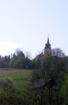 Marija Gorica district encompasses 17.10 km2 and 2,089 inhabitants (2001) and is mostly hills and a smaller portion on the west side along the Sutla river, the border between the Republics of Croatia and Slovenia. The southeastern border is with Brdovec district, the northwestern with Pušća district and in the north is the Dubravica district. The highest geographic point is Kipišće hill (312 m) and Lipa (297 m), as well as Sveti Križ at the altitude of 310 m with the Belvedere of Sveti Križ and the view over the Sava river valley to Samobor and Žumberak hills all the way to Velika Gorica. There is the Medvednica mountain in the east, and the view to the south stretches to the Macelj hills. To the west there is the Slovenian side of the Sutla and Sava rivers, the towns of Brežice, Krško and Slovenian hills. The view stretches to the snowy Alps. Marija Gorica was first mentioned in 1501. It was formerly known as Sveta Gorica and changed the name after the Franciscans came from Bosnia running from the Turks and brought with them the miraculous statue of the Mother of God. Several famous persons were born in Marija Gorica, among them Ante Kovačić (born in Oplaznik in 1854). On the Feast of St. Peter and Paul (June 29) there is a celebration for the "Days of Ante Kovačić".
Address: Gorička 17 , 10299 Marija Gorica
Tel: 01 3396 445; 3396 655
Fax: 01 3396 445
E-mail: opcina.marija.gorica@zg.htnet.hr
Web: http://marija-gorica.hr
Objects on borough area
Chapel of the Holy Cross
Belvedere in Sv. Križ Brdovečki
Church of the Blessed Virgin Mary of the Visitation